


توضیحات Austrian Map mobile
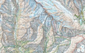
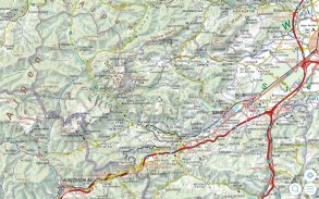
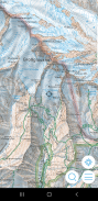
The Austrian Map mobile (AMap mobile) contains the digital maps of Austria including hill shading, geographic names database “Geonam” and the digital elevation model. This digital product of the Bundesamt für Eich- und Vermessungswesen (BEV) offers high quality topographic maps and a user-friendly interface with extensive functionality.
Maps and data available in the Austrian Map mobile:
* Overview Map 1:1 Million (free of charge)
* Cartographic model 1:500 000 (free of charge)
* Cartographic model 1:250 000
* Cartographic model 1:50 000
The app contains a map tile contingent of 550 tiles, which corresponds to 550 km ² in the scale 1:50 000 (no specific area, maps free to choose). This allows to test the capabilities of the AMap mobile in a specific area. Additional areas may be downloaded at will.
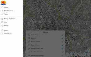
Functions of Austrian Map mobile:
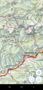
* Search by toponym or search by coordinates
* GPS features: Display of the location, "moving map", compass support, routing along tracks
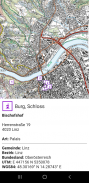
* Insert, edit and share POIs (Points of Interest)
* Recording and exporting tracks (tracks can be imported into AMap Fly)
* meta data about the used map sheets
همراه نقشه اتریش (همراه AMap) شامل نقشه های دیجیتال از اتریش از جمله سایه تپه، نام جغرافیایی پایگاه داده "Geonam" و مدل رقومی ارتفاع. این محصول دیجیتال می Bundesamt خز UND Eich- Vermessungswesen (BEV) ارائه می دهد نقشه های توپوگرافی با کیفیت بالا و رابط کاربر پسند با قابلیت های گسترده.
نقشه ها و داده های موجود در تلفن همراه نقشه اتریشی:
* بررسی اجمالی نقشه 1: 1 میلیون (رایگان)
* مدل وابسته به نقشه کشی 1: 500 000 (رایگان)
* مدل وابسته به نقشه کشی 1: 250 000
* مدل وابسته به نقشه کشی 1:50 000
برنامه شامل مشروط نقشه کاشی از 550 کاشی، که مربوط به 550 کیلومتر مربع در مقیاس 1:50 000 (بدون منطقه خاص، نقشه های رایگان را انتخاب کنید). این اجازه می دهد تا برای تست قابلیت های تلفن همراه AMap در یک منطقه خاص. مناطق اضافی ممکن است در اراده دانلود.
توابع از اتریش نقشه همراه:
* جستجو توسط toponym یا جستجو بر اساس مختصات
* ویژگی های GPS: صفحه نمایش از محل، "نقشه حرکت"، پشتیبانی قطب نما، مسیریابی به همراه آهنگ
* درج، ویرایش و به اشتراک گذاری POIs (مکان های مورد علاقه)
* ضبط و آهنگ های صادرات (آهنگ را می توان به AMap پرواز وارداتی)
* داده های متا در مورد ورق های نقشه استفاده می شود
Austrian Map mobile - نسخه 2.1.3
(20-10-2022)Austrian Map mobile - اطلاعات APK
نسخه APK: 2.1.3حزمة: com.garzotto.ammaاپلیکیشنها در دسته مشابه
شاید دوست داشته باشید...


